Kirby Mapnotator
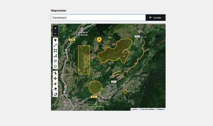
Annotate maps and generate GeoJSON in Kirby by drawing markers, paths and shapes.
Overview
This plugin is completely free and published under the MIT license. However, if you are using it in a commercial project and want to help me keep up with maintenance, please consider making a donation of your choice through GitHub Sponsors or Paypal or purchasing your license(s) through my affiliate link.
1. Installation
Download and copy this repository to /site/plugins/mapnotator
Alternatively, you can install it with composer: composer require sylvainjule/mapnotator
2. Setup
Out of the box, the field is set to use open-source services both for geocoding (Nominatim) and tiles-rendering (Positron), without any API-key requirements.
Keep in mind that these services are bound by strict usage policies, always double-check if your usage is compatible. Otherwise, please set-up the field to use Mapbox, see details below.
mymap:
  label: My map
  type: mapnotator
3. Tile-servers
3.1. Open-source / free tiles
You can pick one of the 4 free tile servers included:
wikimedia(Terms of Use)openstreetmap(Terms of Use)positron(default, Terms of Use [Under Free Basemaps Terms of Service])voyager(Terms of Use [Under Free Basemaps Terms of Service])
mymap:
  type: mapnotator
  tiles: positron
You can also set this globally in your installation’s main config.php, then you won’t have to configure it in every blueprint:
return array(
    'sylvainjule.mapnotator.tiles' => 'positron',
);
3.2. Mapbox tiles
mapbox.outdoors→mapbox/outdoors-v11(default mapbox theme)mapbox.streets→mapbox/streets-v11mapbox.light→mapbox/light-v10mapbox.dark→mapbox/dark-v10
In case your usage doesn’t fall into the above policies (or if you don’t want to rely on those services), you can set-up the field to use Mapbox’ tiles.
You will have to set both the id of the tiles you want to use and your mapbox public key in your installation’s main config.php:
return array(
    'sylvainjule.mapnotator.mapbox.id'    => 'mapbox/outdoors-v11',
    'sylvainjule.mapnotator.mapbox.token' => 'pk.vdf561vf8...',
);
You can now explicitely state in your blueprint that you want to use Mapbox tiles:
mymap:
  type: mapnotator
  tiles: mapbox
You can also set this globally in your installation’s main config.php, then you won’t have to configure it in every blueprint:
return array(
    'sylvainjule.mapnotator.tiles' => 'mapbox',
);
4. Geocoding services
4.1. Open-source API (Nominatim)
This is the default geocoding service. It doesn’t require any additional configuration, but please double-check if your needs fit the Nominatim Usage Policy.
mymap:
  type: mapnotator
  geocoding: nominatim
4.2. Mapbox API
In case your usage doesn’t fall into the above policy (or if you don’t want to use Nominatim), you can set-up the field to use Mapbox API.
If you haven’t already, you will have to set your mapbox public key in your installation’s main config.php:
return array(
    'sylvainjule.mapnotator.mapbox.token' => 'pk.vdf561vf8...',
);
You can now explicitely state in your blueprint that you want to use Mapbox as a geocoding service:
mymap:
  type: mapnotator
  geocoding: mapbox
With Mapbox API comes the ability to autocomplete your search. It is activated by default, you can deactivate it by setting the autocomplete option to false.
mymap:
  type: mapnotator
  geocoding: mapbox
  autocomplete: false
You can also set this globally in your installation’s main config.php, then you won’t have to configure it in every blueprint:
return array(
    'sylvainjule.mapnotator.geocoding' => 'mapbox',
);
5. Per-field options
5.1. center
The coordinates of the center of the map, if the field has no stored value. Default is {lat: 48.864716, lon: 2.349014} (Paris, FR).
Once the field has at least one shape drawn, it will automatically find its initial center in order to display all the shapes.
mymap:
  type: mapnotator
  center:
    lat: 48.864716
    lon: 2.349014
5.2. zoom
The min, default and max zoom values, where default will be the one used on every first-load of the map. Default is: {min: 2, default: 12, max: 18}.
Once the field has at least one shape drawn, it will automatically find its initial zoom level in order to display all the shapes.
mymap:
  type: locator
  zoom:
    min: 2
    default: 12
    max: 18
5.3. shapes
The shapes your editors are allowed to draw on the map. They are all activated by default:
mymap:
  type: mapnotator
  shapes:
    - marker
    - polyline
    - rectangle
    - polygon
    - circle
    - circleMarker
5.4. tools
The tools / shape modifiers your editors are allowed ot use. They are all activated by default:
mymap:
  type: mapnotator
  tools:
    - edit
    - drag
    - cut
    - remove
    - rotate
5.5. size
The height of the field. Default is full, which will make the field fill the entire height of the viewport. Options are:
full(entire viewport height)large(fits all buttons in the toolbar)medium(fits 8 buttons in the toolbar)small(fits 6 buttons in the toolbar)
5.6. color
You can change the shapes / markers color by setting this option to any valid color value. Default it blue (#2281f7).
mymap:
  type: mapnotator
  color: '#2281f7'
6. Global options
The same options are available globally, which means you can set them all in your installation’s config.php file and don’t worry about setting it up individually afterwards:
return array(
    'sylvainjule.mapnotator.token'        => '',
    'sylvainjule.mapnotator.id'           => 'mapbox.outdoors',
    'sylvainjule.mapnotator.tiles'        => 'positron',
    'sylvainjule.mapnotator.zoom.min'     => 2,
    'sylvainjule.mapnotator.zoom.default' => 12,
    'sylvainjule.mapnotator.zoom.max'     => 18,
    'sylvainjule.mapnotator.center.lat'   => 48.864716,
    'sylvainjule.mapnotator.center.lon'   => 2.349014,
    'sylvainjule.mapnotator.shapes'       => ['marker', 'polyline', 'rectangle', 'polygon', 'circle', 'circleMarker'],
    'sylvainjule.mapnotator.tools'        => ['edit', 'drag', 'cut', 'remove', 'rotate'],
    'sylvainjule.mapnotator.size'         => 'full',
    'sylvainjule.mapnotator.geocoding'    => 'nominatim',
    'sylvainjule.mapnotator.autocomplete' => true,
    'sylvainjule.mapnotator.color'        => '#2281f7',
);
7. Front-end usage
The GeoJSON is stored as YAML and therefore needs to be decoded with the yaml method.
$location = $page->mymap()->yaml();
You can then encode it to JSON using Kirby’s toolkit:
$json = Json::encode($location);
7.1. circle and circleMarker
The GeoJSON syntax doesn’t support circles or circleMarkers. They are stored as a point by default (see this Medium post for more details).
Therefore, the field stores additionnal properties alongside their coordinates, to allow you to recreate them in your projects:
{
    "type": "Feature",
    "properties": {
        "shape": "CircleMarker"
    },
    "geometry": {
        "type": "Point",
        "coordinates": [6.862806, 47.967742]
    }
},
{
    "type": "Feature",
    "properties": {
        "shape": "Circle",
        "radius": 241.85391410521
    },
    "geometry": {
        "type": "Point",
        "coordinates": [6.84809, 47.969121]
    }
}
When importing the GeoJSON into your project, you will need to check for those properties in order to transform them into the appropriate shapes. With Leaflet, for example, it would look like:
L.geoJSON(myGeoJSON, {
    pointToLayer: (feature, latlng) => {
        if (feature.properties.shape == 'Circle') {
            return new L.Circle(latlng, feature.properties.radius);
        }
        else if (feature.properties.shape == 'CircleMarker') {
            return new L.CircleMarker(latlng);
        }
        else {
            return new L.Marker(latlng);
        }
    }
}).addTo(myMap)
8. Credits
Services:
- Openstreetmap, Carto or Mapbox as tile servers.
- Nominatim or Mapbox Search as a geocoding API
- Leaflet as a mapping library.
- Geoman as a GeoJSON editor.
9. License
MIT
